4. Technical Reports

4.2 Other IERS Related Technical Development Activities


The Status of SLR R&D Experiment (Hiroo Kunimori)

Table . Summary of Activities
Classification Project Name Fiscal Year Status Summary
Geodetic Observation and Analysis Earthquake Prediction Measurement in Metropolitan Area 1990-1995 -Comparison Results of Coordinates from collocation of SLR,VLBI and GPS in MDX exp.
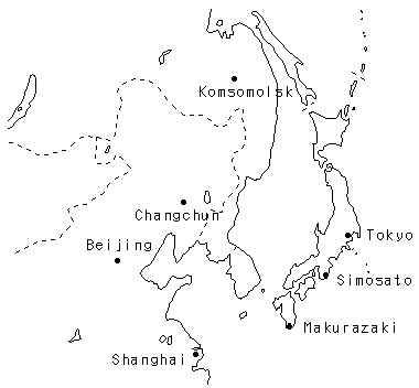
Evaluation of Earthquake Potential in East Edge of the Japan Sea 1994-1996 -Improvements of range bias calibration -Short arc solution of station position by Ajisai tracking campaign in east Asia networkiFig.9 and Table 2)
International Network Western Pacific Laser Network 1994- -WPLS Symposium at Canberra -Japan as Secretariat of WPLS (Australia, China Japan and Russia)
Next Generation R&D Synchronous Laser Ranging System 1992-1994 -Synchronous Timing Precision : 70ns
Orbit Determination of Remote Sensing Satellite 1995- -System Design of Laser Radar to ADEOS satellite
Spin Observation of AJISAI 1994-1995 -Prototype system
Eye-Safe Laser Ranging System 1994- -Introduction of Raman-1.5um generation and SPAD detector system
KSP SLR System
(1995-j -Phase of Specification


Figure 9. The stations participated in AJISAI tracking campaign (SLR-Japan)

Table 2. The short arc solution of station position in SLR-Japan.
Station
Coordinates Internal Error Deviation from ITRF92 Error in ITRF92 (Analysis)
Tokyo(7308) x -3942020.074 0.007 0.085 0.116 (Single-pass)
y 3368097.479 0.007 -0.067 0.112
z 3702191.094 0.007 0.044 0.138
Tokyo(7308) x -3942020.066 0.015 0.093 0.116 (SRD)
y 3368097.464 0.017 -0.082 0.112
z 3702191.093 0.005 0.043 0.138
Shanghai(7837) x -2831087.946 0.025 -0.004 0.011 (Single-pass)
y 4676203.317 0.024 -0.021 0.011
z 3275172.789 0.026 0.018 0.012
Changchun(7237) x -2674386.952 0.031 -0.048 0.084 (Single-pass)
y 3757189.569 0.026 0.067 0.068
z 4391508.492 0.024 -0.150 0.053
Komsomolsk(1868) x-2948543.462 0.850 (Single-pass)
y 2774313.435 0.496 Not listed in ITRF92}
z 4912307.097 1.026
Simosato fixed UNIT:METERS

Q&A

Q: Why do VLBI results (for Koganei) have larger errors than those from GPS?
A: No ionospheric correction is applied for this case. Moreover, VLBI measurements were only made seven times in a span of 6 years, but GPS measurements were made only for three days. Thus they can not be compared with each other directly.


Return to CONTENTS