1Communications Research Laboratory
4-2-1 Nukui-kita, Koganei, Tokyo 184-8795, Japan
2 Kashima Space Research Center
Communications Research Laboratory
893-1 Hirai, Kashima, Ibaraki 314-0012, Japan
1. Intoroduction
VLBI and SLR revealed the current plate motion within a precision less
than 1mm/year. Recently, GPS are observed the detail crustal deformation
in dense. It is important to compare the data reliability between these
measurements (VLBI, SLR, GPS)
CRL (Communications Research Laboratory) had established the
domestic network of the Crustal
Deformation Monitoring System in the Tokyo Metropolitan Area.
We call this projects "Key Stone Project (KSP)".
The KSP is useful to compare the results among VLBI,
SLR and GPS. The four stations are Koganei in Tokyo, Kashima
in Ibaraki, Miura in Kanagawa and Tateyama in Chiba. The baseline
lengths are from 30km to 110km.
The VLBI antenna is 11m antenna and SLR is 75cm
optical telescope.
Almost daily 5 hours VLBI observation was started
since 31th January in 1995 in the mode of 56Mbps on the
baseline of Kashima and Koganei. The Miura and Tateyama stations were
participated in the VLBI experiments on December 1995 and on September
1996, respectively. The daily 5 hours VLBI observation in the mode
of 256Mbps was started on 19th February 1997.
The 24 hours VLBI experiments
were started on 30th September 1997 every other day.
The real time VLBI system has been available
in our project (KSP) in cooperation with NTT company in Japan
since April 1997. The
correlation is done in real time. The SLR observations
were started in 1997. There are GPS stations of GSI near
KSP stations within a few km as stations of the dense GPS network in
Japan constructed by GSI. The data of GSI and KSP data were opened
by WWW. The GPS station near Miura is not good, and we use the GPS data
of Yokosuka station a little far from Miura. Other GPS stations are
located a few km within the VLBI stations. We can compare the VLBI data and GPS data.
At first, we compare the data quality of VLBI with GPS in
this network. The quality and reliability of VLBI and GPS data
are obtained in the domestic network. Secondly, we indicate the variations
with the periodic terms of one month to one year for both VLBI and GPS
data. We are interested in the
true and pseudo variation of the station position.
2. Comparison of VLBI and GPS data
2.1 Velocities
The velocities of Koganei, Miura, Tateyama stations relative to Kashima
stations are compared. The measurement error of velocities in KSP are
0.2mm-0.5mm/year for horizontal movements, and 1-2mm/year for vertical
movements. The measurement errors of GPS stations are similar to VLBI data.
The velocities of GPS stations are different from the velocities of VLBI
stations. The discrepancy is 0.7mm/year for the horizontal movements of Koganei
station and 2mm/year for other stations. It is 3 times of the measurements
error. The discrepancy of vertical movements is greater than 8mm/year. The
vertical movements is not uncertain for the short period.
2.2 Data quality and reliability
We investigate the data quality and reliability of VLBI data in KSP and GPS
data. Since 31th January 1995, the 5 hours VLBI experiment in the mode of
56Mbps was started in KSP. There are two epochs when the status of data were
drastically changed. The first epoch was on 19th February in 1997 (epoch 1)
when the observation mode changes to 256 Mbps (still 5 hours observation), and
the second epoch is 30th September 1997 (epoch 2) when the 24 hours experiment
in the mode of 256Mbps was started. The PCAL at Kashima station was improved
near epoch 1, and the quality of the data related with Kashima station was
improved.
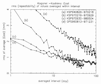
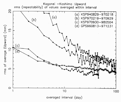
We investigate the r.m.s. of the averaged values within any interval which
the data period is divided into. Figure 1,2 shows the r.m.s. of the averaged
values for the east and upward movements at the Koganei station relative to the
Kashima station. (a) means the data of 5 hours 56Mbps/64Mbps VLBI experiments
till epoch 1. (b) means the data of 5hours 256Mbps VLBI experiments during
epoch 1 to epoch 2, and (c) means the data of 24hours 256Mbps VLBI experiments
since epoch 2. The dispersions of GPS data since August 1996 are also indicated
in the Figures as the data (d).
Figure 1. Comparison of r.m.s of the averaged East-West movements
between VLBI and GPS data (Kashima-Koganei 109 km).
Figure 2. Comparison of r.m.s of the averaged Upward movements
between VLBI and GPS data (Miura-Tateyama 35 km).
The values of 1 day (faster variations) means the error of each data. The
errors of horizontal movements are 4-6mm, 4mm, 2mm and 2mm for 5hours 64Mbps
VLBI, 5hours 256Mbps VLBI, 24 hours 256Mbps VLBI and GPS in this turn. Each
data error of GPS is similar to one of 24hours VLBI data. Each data error of
the vertical movement is 2-3cm, 2cm, 1cm and 1cm in this turn, respectively.
The physical interpretation is mainly revealed by the systematic variation.
However, each errors has a large random variation, and it is difficult to reveal
the physical phenomena. If we average each data, large random errors are
canceled out and the systematic variation appears. Furthermore, we are
interested in the variations with the periodic terms from one month to one year,
that is, seasonal and annual variation. It is important to know how the
position changes beside the velocity. We examine the errors (reliability) of
the variations with the terms longer than one month. For these variations, the
horizontal errors are 1mm, 0.5-1mm and 0.5mm for GPS data, 5hours 256Mbps data
and 24hours 256Mbps data in this turn, respectively. The vertical errors are
5mm, 5mm and 2-4mm in this turn, respectively. In general, the reliability of
the variations longer than one month by VLBI is better than GPS data. The VLBI
data may be stable for the long period than GPS data.
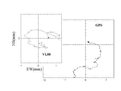
Figure 3. Comparison between VLBI and GPS of pattern of
horizontal movements of Koganei relative
to Kashima from 1997.10.1 (30days shifted average).
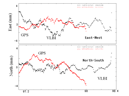
Figure 4. VLBI and GPS variation on Kashima-Koganei 109 km.
2.3 Pattern of the movements
We investigate the horizontal movements. We plot the trace of the horizontal
movements. Each data has a large random error, and we use an averaged value
within a interval. The averaged interval is 30 days, and we use the box average
(shifted average). The systematic variations longer than 30 days are found. We
also compare the pattern of the horizontal movements to check the reliability of
the systematic variations. If the variations are similar between the different
measurements techniques, such as VLBI, GPS and SLR, the variations is true.
Figure 3 shows the patterns of horizontal movements for 24hours 256Mbps VLBI
data and GPS data during October to December in 1997. This is the movements of
Koganei station relative to Kashima station. The right figure is VLBI data, and
the left is GPS. The scale is the same. The pattern of the horizontal
movements for VLBI data is different from one for GPS data. Figure 4 shows the
box averaged values within 30 days for the east and north movements of VLBI and
GPS data on Koganei-Kashima baseline since 1997. The variations vs. time are
found in detail. The large systematic variations of VLBI data is different from
GPS data. However, the fine variations shorter than one week are sometime
similar between VLBI and GPS data. These fine variations may be caused by
atmospheric effects.
We also investigate the variation of whole GPS raw data relative to time. The
GPS data at some stations is seemed to be in annual GPS has a little large
systematic variation for long term at some station. One reason of the
systematic variation in GPS data may be the change of the length and trend of
GPS pole caused by the temperature change.
3. Conclusion
We conclude the comparison between GPS and VLBI data as follows;
1. KSP is the good test-bed to make a comparison among
VLBI, SLR and GPS.
2. 256Mbps 24 hours experiments at KSP is the same
quality as GPS data for each data.
3. VLBI is better than GPS for short term variation
longer than one month.
4. The pattern of horizontal movements of KSP
VLBI data is disagreed with one of GPS data.
5. The variation within one week is agreed with
GPS. It may be caused by the atmospheric effects.
Acknowledgments
The GPS data is produced by GSI (Geographic Survey Institute) in Japan.
We are grateful for GSI staffs.