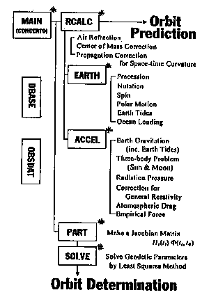
Figure 1. Structure of CONCERTO.
Communications Research Laboratory (CRL) has made SLR obsefvation and has taken the data since 1990. We are now engaged in development of a unique analysis software for SLR, named "CONCERTO" (Computalized satellites' Orbits aNalyzer by CRL spacE and time Research Group in TOkyo) on Sun SPARC workstation.
Numerical standards and algorithm used in CONCERTO are consistent with VLBI analyzer in CRL Kashima. CRL is one of institutions which have both SLR and VLBI observation systems. Though each of the two geodetic methods has attained very high precision, it is difficult to verity their own accuracy. The models and constants in the VLBI analyzer and CONCERTO mostly utilize IERS Standards to compare the results from each other working with a model switcher and databases. It is used for laser ranging analysis such as collocation experiment with VLBI and at present it can be handling with small data volume and number of stations. The functions of CONCERTO are orbit prediction of geodetic satellites orbits, and solution of geodetic parameters.
The functions of modules in CONCERTO are as follows :
| MAIN | : | Supervise whole programs. |
| ACCEL | : | Calculate the modeled accelerations that influence to satellite. |
| EARTH | : | Calculate the position of the observation site in J2000.0 reference frame. |
| RCALC | : | Output the range prediction, using results of two modules above. |
| PART | : | Prepare the partial derivatives by parameters. |
| SOLVE | : | Determine the set of parameters by means of least squares method. |
| OBSDAT | : | Access the SLR observation data files. |
| DBASE | : | Access the data files of physical constants, earth rotation parameters, and so on. |
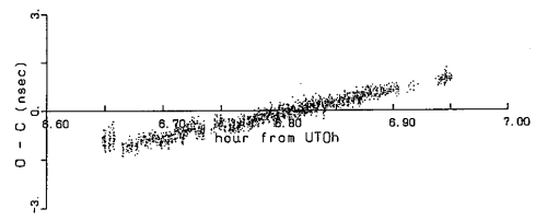
Figure 1 shows the structure of CONCERTO. The blocks marked with "#" are modules under development, ones with "*" have been completed. The other modules will be programmed soon. Figure 2 shows the "O - C" ([observation range value] - [calculated value by CONCERTO]) plot of LAGEOS I 09/24/91 pass. The initial position and velocity vector of the satellite are estimated by software 'UTOPIA' developed in Center for Space Research of University of Texas at Austin.

