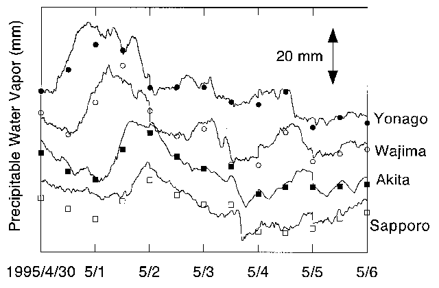
Figure 1. {Comparisons of PWV obtained by routine radiosonde data sets of JMA (circles and squares) and that estimated from GPS analyses (solid lines) at Sapporo, Akita, Wajima, and Yonago (after Ohtani et al., 1996)
Kashima Space Research Center
Communications Research Laboratory
893-1 Hirai, Kashima, Ibaraki 314, Japan
At present, GPS meteorology are considered to be a powerful method for an
understanding of atmospheric variations (Bevis et al., 1994). Moreover, we
expect that GPS meteorology will also contribute an improvement of the
precision of space geodetic techniques.
Japanese cooperate study supported by Science and Technology Agency of Japan, which is titled "Establishment of Water Vapor Information Database by GPS Meteorology and its Applications to Numerical Weather Prediction, Earthquake Prediction Research and Hydrology", have been started as feasibility study in 1996 Japanese budget year. The main objective of the study is to improve the precision of both the numerical prediction for mesoscale phenomena and the detection of crustal movement. Achievement of the objective is attributed to the interaction of two systems: the dense permanent network of GPS sites of Geographical Survey Institute (GSI) and the numerical prediction data with high resolution (20 km grid intervals and 36 vertical levels) of Japan Meteorological Agency (JMA). As of April 1996, there are 610 GPS sites of GSI. By the end of 1996 fiscal year, 250 GPS sites will be added to the present network.
Ohtani et al. (1996) preliminarily reported the estimation of precipitable
water vapor (PWV) by GPS. They confirmed that PWV can be estimated within 3
- 4 mm rms by GPS comparing with radiosonde data sets as shown in Figure 1.
However, there are several study fields which must be carried out to
realize the main objective. These are planning in the cooperate study as
follows.

Figure 1.
{Comparisons of PWV obtained by routine
radiosonde data sets of
JMA (circles and squares) and that estimated from GPS analyses
(solid lines) at Sapporo, Akita, Wajima, and Yonago (after Ohtani et al.,
1996)
VLBI geodesy can avoid uncertainties of satellite orbit determinations and
can independently estimate the tropospheric path delay at each site by long
distance measurements. Thus, it is expected that the residual delay
estimated by VLBI will be more precise using the correction based on
numerical prediction data. The estimated delay is available in the analysis
of GPS data as a priori delay. As a result, we can reduce an unknown
parameter in the GPS analysis. In addition, realtime VLBI analysis is now
under development. Consequently, more precise monitoring of crustal
movements by VLBI and GPS will be carried out with sub-daily temporal
resolution.

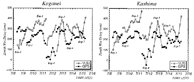
Figure 2.
Time series of zenith tropospheric delay
estimated by VLBI and
GPS analyses at Koganei - Kashima baseline (about 109 km) during 8 - 14
July, 1996. Since a priori delay is not used in this analyses for both VLBI
and GPS, the absolute values are not confident. However, similar
characteristics are shown for both plots by VLBI and GPS; increasing in
Exp.2 (July 9) and Exp. 3 (July 10), and decreasing in Exp. 4 (July 11).
We are now executing a feasibility study for estimating the delay by KSP
network and are preparing for observations comparing with water vapor
radiometer (WVR). Figure 2 shows time series of the zenith delay estimated
by VLBI and GPS analyses at Koganei and Kashima during 8 - 14 July, 1996
(JST). Both plots by VLBI and GPS increase during 9 - 11 July (JST) and
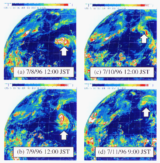
extremely decrease during 11 - 12 July (JST) in a similar manner. According
to the infrared images by a geostationary meteorological satellite of JMA
(GMS5), a typhoon moved northward in the Western Pacific during the
concerned period (see Figure 3). It seems that the variations of the zenith
delay are attributed to the water vapor variation caused by the typhoon
movement though it is a roughly qualitative comparison. For more detailed
interpretation another investigations are required; comparisons with
numerical prediction data and radiosonde data sets, recalculations of
parameter estimations in VLBI and GPS analyses, and so on. The results of
these investigations will be reported in another paper.

Figure 3.
Infrared images by GMS5 of JMA. Arrows as shown
in these figures
indicate typhoon. It is inferred that the variation of water vapor related
to the typhoon causes the temporal variations of zenith delay as shown in
Figure 2.
Ohtani, R., H Tsuji, N. Mannoji, J. Segawa, and I. Naito (1996):
Precipitable Water Vapor Observed by Geographical Survey Institute's GPS
network, Tenki, in submitting (in Japanese).