Research Activities : Space Geodesy
Space Geodesy stands for space based precise measurement
techniques for Geodesy, which include Very Long Baseline
Interferometry (VLBI), Satellite Laser
Ranging (SLR),
and Global Positioning System (GPS).
Radio Astronomy Applications Section is studying Geodynamics
by means of these Space Geodetic techniques, especially VLBI.
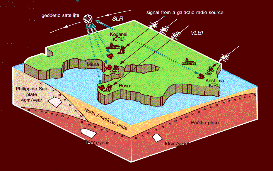
KSP is the project to monitor regional crustal deformations in the Tokyo
metropolitan area by using space geodetic techniques. The KSP has been
started in 1993 by CRL.
 Western Pacific VLBI Network (1989-1994)
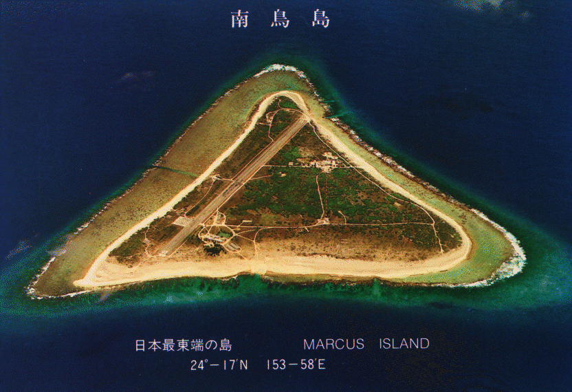
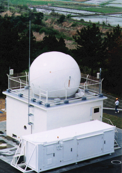
Minamitorishima (Marcus Is.)
Western Pacific VLBI Network (WPVN) was deployed by CRL in 1989 to monitor the
motion of two oceanic plates (Pacific and Philippine Sea plates) around
Japan. The WPVN consists of three Japanese stations and one Chinese station
on the four different plates, i.e., Kashima (North American plate),
Minamitorisima (Pacific plate), Minamidaitojima (Philippine Sea plate),
and Shanghai (Eurasian plate), respectively. We have detected the motion of
Minamitorishima close to the NUVEL-1 plate motion model.
Details of the Western Pacific VLBI Network experiments and related
research topics and developments were presented in the special issue of the
Journal of the Communications Research Laboratory published in 1995
(Journal of the Communications Research Laboratory, Vol. 42, No. 1, 1995).
- I. Introduction by A. Sugiura
- II. Overview of the Experiment System
- II-1. The Main VLBI Station at Kashima by M. Imae et al.
- II-2. Station in the Remote Islands by T. Yoshino et al.
- II-3. The Western Pacific Geodetic Project's Data Acquisition and Processing System by H. Kiuchi et al.
- II-4. Data Processing Software and Data Analysis Software by Y. Takahashi et al.
- III. Geodetic Results of the Experiments
- III-1. Movements of the Minamitorishima Station by Y. Koyama et al.
- III-2. Movements of the Minamidaito Station by J. Amagai et al.
- III-3. Movements of the Shanghai Station : Implication for the Tectonics of Eastern Asia by K. Heki et al.
- IV. Related Results and Activities in Western Pacific VLBI Network
- IV-1. The Metropolitan Diamond Cross Experiments by T. Kondo et al.
- IV-2. Short Report of the Experiments with the Urumqi VLBI Station, Western China by T. Iwata et al.
- IV-3. Collocation and Local-Tie of Space Geodetic Techniques, VLBI, SLR, and GPS in CRL by H. Kunimori et al.
- IV-4. Radio Astronomy with the Kashima 34m Antenna by H. Takaba et al.
- IV-5. Experiments with the Southern Hemisphere by H. Kurihara et al.
- V. Conclusion Toward the Key Stone Project by F. Takahashi
Collaborations with Related Research
Organizations
CRL has participated more than 150 international VLBI experiments
under the Crustal Dynamics Project of NASA using both 26m antenna
station since 1984 and 34m antenna station since 1989.
At present, Geodetic Survey Institute is in charge of 26m antenna station
at Kashima and is participating NASA's Dynamics of Solid Earth Program
(expanded follow-on program of Crustal Dynamics Project).
Precise Earth Rotation Measurements
Kashima 34m antenna station has been participating IRIS-P (International
Radio Interferometric Servey - Pacific experiments coordinated by
IERS) and NAVEX (international campaign coordinated by US Naval
Observatory) for precise Earth rotation measurements.
Domestic Cooperations
Communications Research Laboratory is cooperating with Geographical
Survey Institute, National Astronomical Observatory, Institute for
Space and Aeronautical Sciences, National Institute for Polar
Research and Kagoshima University for domestic VLBI experiments and
technical developments for the VLBI research.
Research Publications
- "Contributions and Activities of Communications Research Laboratory
under the Cooperation with Crustal Dynamics Project", H. Kunimori et al.,
in Contributions of Space Geodesy to Geodynamics : Technology, eds. D. E.
Smith and D. L. Turcotte, Geodynamics Series 25, American Geophysical
Union (1995) pp.65-79
-
"Horizontal Movement of Marcus VLBI Station due to the Pacific Plate
Motion", Y. Koyama et al., Proceedings of CRCM'93, published as a
special issue of the J. Geodetic Soc. Jpn. (1993) pp.117-122
- "Estimation of Errors in VLBI Data and Position Determination Error",
Y. Takahashi, J. Geodetic Soc. Jpn., Vol.40 (1994) pp.309-331
- "Estimations of Atmospheric Excess Path Delay based on Three-Dimensional,
Numerical Prediction Model Data", R. Ichikawa et al., J. Geodetic Soc.
Jpn., Vol.41 (1995) pp.379-408
-
"Excess Westward Velocities of Minamitorishima (Marcus) andin VLBI
Stations in Addition to the Expected Velocities from Rigid Motion of
the Pacific Plate", Y. Koyama, J. Geodetic Soc. Jpn., Vol.42
(1996) pp.43-57
- "Positioning Error in GPS Measurements due to Atmospheric Excess Path
Delay Estimated from Three-dimensional, Numerical Prediction Model
Data", R. Ichikawa et al., J. Geodetic Soc. Jpn., Vol.42 (1996)
pp.183-204
- "Movements of VLBI Stations and the Effects of Ionospheric Delay
Corrections on the Positions of the Domestic Experiments in Japan",
Y. Takahashi et al., J. Geodetic Soc. Jpn., Vol.43 (1997) pp.45-65
-
"Evaluation of repeatability of baseline lengths in the VLBI network
around the Tokyo metropolitan area", Kondo et al, Geophys. Res.
Lett., 25 (1998) 1047-1050
Please send any questions and comments to us.
Return to Radio Astronomy Applications Section
Last Update: July 3, 1998